Sabtu, 29 November 2008

Critters in the snow


This fox squirrel didn't seem to be intimidated by the snow. He was as boistrious and cocky as ever.

We have finally had our first snow here in Denver. The birds and squirrels were dealing with the chill in different ways. The birds were chirping away in the stark branches while the squirrels were taunting the dogs. Being a primate, I was coping with the chill by sitting in the hot tub and admiring the cacophony from the comfort of 102 water.


A flicker and several sparrows huddle in an Aspen tree. The flicker rarely stayed still for long.

Jumat, 28 November 2008

Secret Hike near Allenspark


When lakes dry up they slowly turn into meadows. This small one was turning golden in the Fall.

It is the day after Thanksgiving and going over some recent hikes. On this day, two friends and I wandered off the beaten path near Allenspark. So close to Estes Park, the trails are usually mobbed. This unmarked area was deserted and we found some stunning views, and wonderful picnic spot, and a meadow turning golden with the change of seasons. For large sums of money, I might reveal the location of this hike, but your credit better be good!


Mt. Meeker (13,911 ft)


View from the trail. St. Vrain Mountain (12,162 ft) on the left.


Rocks formations in St. Vrain Canyon


My friend John. Perhaps you can bribe him to show you his secret hike!

Stained Glasss in the Allenspark Community Church

This fall, I went hiking with a friend up near Allenspark (Boulder County...Elevation 8,504 ft). He took me to check out the stained glass in the Allenspark Community Church. Each one of the windows represents a different Colorado Wildflower. The church was not open, so I ended up taking pictures of the stained glass through the windows themselves. They are quite striking. If you are visiting Estes Park, or driving the Peak-to-Peak highway for a Sunday drive, stop in. Add a late breakfast as the Meadow Mountain Café and you have the makings of a lovely outing. The artist used to have a web site that described his work and some history of the church. This web site is no longer working.


Reflection of the window with hints of Allenspark beyond


Golden Banner window


Outside of the church

Matthew Winters Park

Distance: 4.5 miles RT
Elevation: 6,200 - 6,771 ft
Elevation Gain: 1, 296 ft cumulative (lots of ups and downs)


The south side of the Morrison Slide Trail at Matthew Winters Park

Matthew Winters is a close in Jefferson County Open Space with unique views of Red Rocks and the Morrison Valley. It is a tour through geologic history. In the spring, the nearby Dakota Ridge Trail is home to migrating raptors. The best time to visit is during the week. On weekends and after work, hikers and mountain bikers mob the park.


Starting out on the Village Walk Trail


Looking back on the Red Rock Trail from the north side Morrison Slide Trail


The Morrison Valley from the middle of the Morrison Slide Trail. The Dakota Ridge is visible in the distance with city of Denver beyond.

My favorite route starts with the west side of the Village Walk Trail. This short 0.3-mile trail wanders uphill through waving grasses and passes an ancient cemetery. It connects with the Red Rocks Trail, which continues upwards along the side of a sloping hill. The views increase as the trail winds westward. Deer can be seen far below in the narrow shrub filled canyon that parallels the route. After 0.8 miles, the hiker descends into this canyon where two options present themselves. One can head steeply up to the Morrison Slide Plateau or head down below the plateau. I always choose to head upwards first. And return via the lower route. The upward route is the Morrison Slide Trail.


Another view of the Morrison Valley


Red Rocks from the Morrison Slide Trail

The Morrison Slide Trail (1.2 miles) if very scenic indeed. Once on top of the plateau, the views extend out into the plains and down the Morrison Valley. The uplift of the Dakota Ridge formation is startlingly evident and the observer can follow the layers of sedimentary rock going back to the Permian Age. These layers are now fins of uplifted rock that make up the Red Rocks Amphitheatre, and they extend all the way down the valley. The far side of the Morrison Slide Trails takes the hiker back down the south side of the Plateau and wanders among large red rock boulders and fins. There are numerous lookouts and picnic spots along the end of the Plateau. This area is also exceptional for a full moon hike.


Looking back on the Morrison Slide trail


Morrison Slide trail

At the end of the Morrison Slide Trail, the hiker can loop back via the lower portion of the Red Rocks Trail, or continue southward for another 1.2 miles to Red Rocks itself or to the connection on the other side of Hwy 26 of the Dakota Ridge Trail. I have never done either of the last two options. The return via the lower Red Rocks Trail (0.8 miles to the junction) is somewhat anticlimactic after all the rock formations, but it is open to the wide sky, which is on of the things I love best about Colorado. I always take the east fork of the Village Walk Trail (0.6 miles) for variety and to make the route longer.


Red rock formations coming down the south side of the Morrison Slide Trail

Matthew Winters Park is a haven for runners, hikers, bikers, but not necessarily dogs. As with all Jefferson County Open Space, dogs must be leashed and the trail is narrow, which make trail passing a challenge. Choose an off-hour time, however and you will have the park nearly to yourself.


More rock formations

Selasa, 25 November 2008

Minggu, 23 November 2008

Button Rock Preserve/Sleepy Lion Trail

Distance: 6 miles RT
Elevation: 5,960 – 6,420 ft
Elevation Gain: 460 ft


Ralph Pierce Reservoir viewed from the Sleepy Lion Trail. You can see Mt. Meeker in the distance.

Button Rock is a delightful and lesser-known open space just west of Lyons. It is dog friendly, contains views of distant Twin Sisters, and skirts a narrow reservoir bordered by pine trees. It is another of my favorite shoulder season hikes.


Creek along the initial part of the trail to the dam

The trail starts off in a large dirt parking area surround by high cliffs. On the west side of a wide gate, a broad flat road heads east towards the Ralph Price Reservoir. The road transects the canyon and with several interesting water features. If you continue heading west, you will end up at the base of the dam, but for a more interesting route, take the Sleep Lion Trail around a half-mile up the road. A large sign marks the trail.


These man made falls are about half-way to the Sleepy Lion turn off.


Rocks along the Sleepy Lion Trail

The Sleepy Lion Trail winds through Ponderosa and Douglas fir. There are occasional open meadows and isolated red boulder formations. At the high point you can see the tip of Mt. Meeker and the double hump of Twin Sisters. There are also views of the reservoir itself.


Twin Sisters in the distance

From the highest vantage, the trail descends down and old rail bed to the base of the dam. Here a dramatic jet of water shoots out of the reservoir’s water control feature. It is difficult to pull oneself away from the chaotic and powerful display of man’s attempt to control nature.


The Ralph Pierce Reservoir seen from the Sleepy Lion Trail

On the far right-hand side of the dam is a short but steep trail up to the reservoir itself. This ascends several hundred feet through several highly eroded areas. Anyone used to Colorado’s steep ascents will find this short jaunt to be trivial. For those who wish an outing that is easier on the knees, skip the trail and head back down the broad road to the trail head.


The old rail bed portion of the Sleepy Lion Trail

The Ralph Price Reservoir is an interesting and rarely visited place. There is no official trail that circumnavigates it, but you can walk along the right shoreline for a mile or so. In low years, there are boulders to nestle in and in high years, the deep blue waters of the reservoir lap the shoreline almost to the level of the trail. If the wind is not blowing too much, this is a pleasant place for a picnic.


Water jet


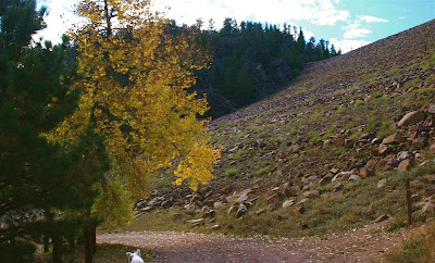
Base of the Button Rock Dam

To return to the trail head, the hiker has two options, he can return down to the base of the dam via the steep trail or wander up and around to one of the dirt roads that skirt the area.


The deep blue of the Ralph Pierce Reservoir

On a sunny fall day, Button Rock can be a pleasant Front Range excursion. While known to the locals, it is rarely visited by those outside of Lyons. This does not mean that it will be uncrowded, however, but I have found that most visitors stay on the main road and do not take the more scenic but more strenuous Sleep Lion Trail.

Kamis, 20 November 2008

2009 Long layered hairstyles

2009 long hairstyles Long layered brunette hair is given dimension and movement using back to back slabbing slices alternating honey and cool topaz foils to feature the layering around the facial area. A rich mocha brown base color is applied everywhere else to frame and add depth and shine to the long hair giving a multi-textured finished look.

Selasa, 18 November 2008

Minggu, 16 November 2008

Naturally Curly Haircuts

Naturally Curly Haircuts - JenniferNaturally Curly Haircuts [image:curly-hair-styles-magazine.com]
Her curly hairstyle looks so great! this long black curly African American hairstyle suits oval face

Kamis, 13 November 2008

Aphrodite Fritillary

Ok, it is still decently warm in Colorado but I am already bemoaning that winter is nigh so I was going back over some photographs I took one day at lunch on Boulder's Mesa Trail this spring.

This butterfly was only still for two seconds, so I was lucky to get it in focus. I believe it is an Aphrodite Fritillary (Speyeria aphrodite) although there are several butterflies that look similar and you really need to see their underwing to get an accurate identification.


The females lay eggs on violet plants but will feed on any type of flower. Unlike some of their moisture loving cousins, they are found in the plains. It was HOT this past summer if you recall. You know it is hot when the poison-ivy was wilting.

Fritillary by the way is a fancy term that means a "butterfly with brownish wings marked with black and silver"

Senin, 10 November 2008

Eagle Wind Trail: Rabbit Mountain Open Space

Distance: 4 miles RT
Elevation: 5, 520- 5,921 ft
Elevation Gain: 401 ft


On the east side of the loop looking north

Rabbit Mountain is a great shoulder season hike. It has incredible views of the continental divide, provides a glimpse into prehistoric Colorado history, and is generally free of snow. I should clarify here. By prehistoric, I mean dinosaur tromping historic. Rabbit Mountain is an uplift of sedimentary rock that was formed when much of the Great Plains consisted of an inland sea. The western edge of the trail leads to several overlooks that sit atop exposed portions of these rocks. On a sunny spring day, they would make an excellent al fresco dining spot.


Pavilion and trail head


Standing on the Morrison formation looking north.


Same formation, looking south


Looking west

The trail begins at a nice pavilion and quickly ascends 300 or so feet to a broad saddle. At one half of a mile, a junction allows the hiker to choose the short but scenic Little Thompson Overlook Trail (2 miles RT) or the longer Eagle Wind Trail (3 miles RT). Combining these two trails can be very nice. The first trail provides lovely views of the Little Thompson while the second trail wanders over grassy slopes with views of the Continental Divide.


On the east side of the loop looking west. You can see Twin Sisters, Longs Peak, Mt. Meeker, and many other peaks from the trail.

On this trip, we chose the Eagle Wind Trail. This trail is very rocky and can be a mud bath after a good rain or snow. It only gains 100 ft or so over its length. Most of the views exist on the right fork of the loop so you can hit them at the beginning or end of your hike. The trail is multi-use, so be emotionally prepared for lots of dogs (on leash), mountain bikers, and horses. We saw all of the above on this trip.


On the east side of the loop, looking north

There are not a lot of trees on the trail but plenty of shrubbery. In the warmer months, songbirds seem to gather here in droves. Bring a pair of binoculars and a picnic dinner and listen to the Meadow Larks sing their melodic song of the plains.


True Mountain Mahogany (Cercocarpus montanus). Grows in dry and sunny areas up to 8,500 ft. The curly reproductive mechanism enables the plant to spread its seed up to 450 ft away. On this trip the hillside was filled with them. They glittered in the sun.

Pengikut